
Artist Christoph Gielen has created a work of art that we consider to be both beautiful, terrifying, and hugely important. The book Ciphers: Decoding the Growth Machine collects his photographic aerial studies of infrastructure in its relation to land use in the United States. The fascinatingly abstract images reveal society of immense technological prowess but with little understanding of its own environment, or way humans want or need to live in the 21st century. While his images span the entire country, we were especially struck by his beautiful images of Southern California freeways, as the invoke the complex and problematic relationship we have to our car-obsessed city and culture. We reached Gielen by email to discuss sprawl, his techniques, goals, and equipment, and of course his favorite taco spot...
Your images can appear as abstractions, but in many ways they are the opposite of that as they are specific locations. The developments are"planned" and "cookie-cutter" but also precise places on earth. Have you come to notice distinct regional characteristics?
Variances in neighborhood planning commonly show along socio-economic lines – but less so regionally. Most anywhere, places with sprawl tend to express themselves as clusters of single-use family homes, and always a car-ride dependent distance away from everywhere. Their architectural expression is one of predictable standardization that we’re all familiar with.
Talking about sprawl isn’t new – but I hope my method for addressing it is.
At best, I feel that with Ciphers I can awaken a yearning for an ecological symbiosis between nature, society, and the built form. Discussing this topic is relevant, now – I could point to any number of wake-up calls, but would like to mention the recent rebuilding efforts in the Hurricane Sandy aftermath in particular.
Can we learn something specific about Southern California's developments and projects that are unique to our part of the world?
Water management issues and water as an essential resource are clearly more significant in California. But in practical terms, aiming for a more sustainable approach would require very similar principles all across the U.S. I am not an expert on land use, or on shaping policy. However, I can report that new trends toward seriously considering what it means to build sustainably exist. Architecture schools in California, and the world over, are going through a discipline change toward Sustainability.
But regardless of region, all new housing should aim at a densification of already existing neighborhoods. We should be focusing on zoning that fosters multi-use development, mixing and re-connecting places of work, living and leisure.
Any new constructions of far flung exurbs with large homes in the middle of nowhere should be discouraged. We need to see a switch away from what are essentially monocultures to complete, human-scale communities.
But any change must include improvements in transportation and infrastructure, both in available modes of transportation, and in transportation habits. I’d like to see a highly functional public transport system, in addition to current highways and as a viable alternative to them. One that’s on par with the rest of the advanced world. This would include quick light rail links into metropolitan regions, and within them. As well as a re-newed focus on railways between all major cities – which we had here, a century ago. A vigorous fostering of bike-use would also help. Davis in California is a good example: Davis is often cited as the most bike-friendly city in the U.S. 16% of all folks there commute to work on bike and it has the lowest traffic fatalities on record.
I’d also like to see a more widespread use of energy saving systems, for example a principle called “passive heat gain”. This is a very basic building concept – not at all rocket science – that we could already be implementing everywhere. It merely requires the orientation of a house to be positioned to deflect the summer sun for providing passive cooling, while allowing the steeper-angled winter sun to enter the structure through large windows for heat retention. Such systems can also optimize the conversion of sunlight into usable heat for water, air, or air-movement for ventilation.
What emotions do you feel when you are capturing the images, and has that changed since you began the project?
I experience the locations as fascinating, and often as profoundly unsettling. The planning of the neighborhoods I end up photographing are really bewildering – but also quite alluring! I’ve always had an obsession with housing, a heightened sense of space. But my feelings on sprawl haven’t really changed over the course of making the project. Rather, I’m focused on what I set out to do. Which is to startle viewers into a re-consideration of how they live. Showing an end-stage, a completed development as part of the land – producing a link between the planning community and the general public, a link between the landscape and its conditions, and those who live in it – I see that as the function of my photography.
I found that I could alert an audience to specific land-use details by producing an aesthetic experience of its manifestations, if I was able to generate a “sprawl encounter” that left them with a sense of foreboding, of seeing the “writing on the wall”. And I play with that. I utilize the formal allure of these settlement layouts to captivate my audience.
Do you experience life on the ground differently now? For example, when you are driving on a freeway interchange, do you imagine yourself from above?
I have certainly grown more aware of our fossil fuel consumptive life-styles when I see clusters of oversized, single-use homes, or end up driving along endless stretches of road simply to be able to reach any number of daily destinations. But while passing through, for example, a 2002 development in San Bernadino County by CalTrans and E.L. Yaeger, which joins two freeways along the 210 route – I might have no idea whatsoever that this flat, 4 square miles-devouring interchange when seen from above would turn into the most splendid abstraction: a chaotic road mass with multiple parallel roads and connecting ramps.
Do you have a particular favorite development, or image or both? What about it makes it a favorite?
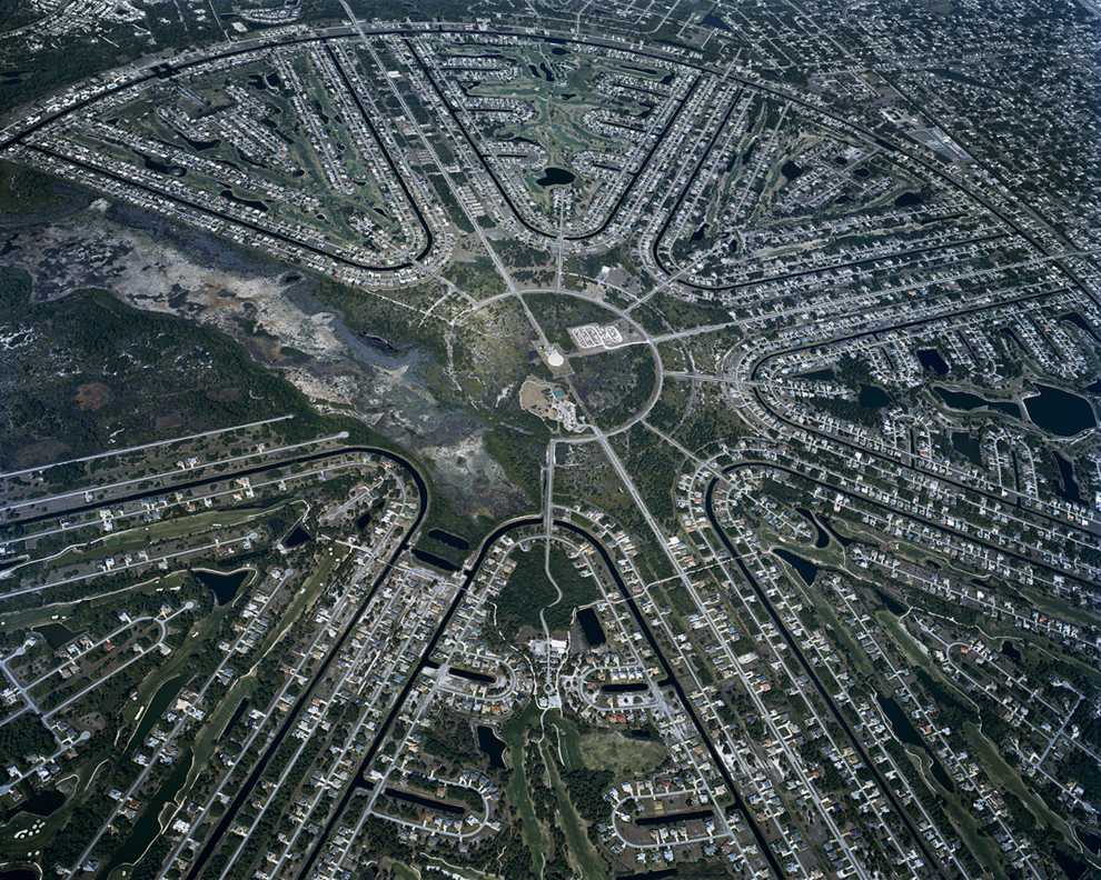
The more outlandish landscape concepts are usually part of designs for private communities – some of them completely over the top, and also clearly discernible from the air. And those are the places, I’d often zero in on.
Of course I have my favorites, but if pressed for my top location, I would site an alien-looking settlement in coastal Florida, in Charlotte County right at the sea. It looks like a design NASA might have come up with in the 50s. The formation itself emerges in my pictures not unlike a gigantic crop circle and measures more than 3 miles across. It has some very large-scale water features, and I was so captivated by its characteristics that I felt compelled to photograph this development on multiple occasions, usually at dawn. Most of the homes inside of this sparsely populated ring have access to a star-shaped canal system for their boats, but each channel segment is unconnected to a much larger circumference channel, or the nearby sea. So it’s unclear where the residents would actually go. There is no real transportation purpose to this planning. It’s design function is mainly aesthetic.
Is your work political?
The work is intended to function at the intersection of photography and environmental politics. I specifically made this project to make a case for sustainable planning, but from an artist’s perspective. I wanted to draw a connection between the built environment, building practices, and climate change. My goal with Ciphers is to examine the ramifications of building trends—well beyond American borders, and to bring about an understanding of growth machines that systematically generate more car-dependent, low-density, developments. Sprawl is a growth model that demands resources and space—both are becoming increasingly limited. If we are really serious about cutting down on carbon emissions it will require us to actually grasp the implications of our growth patterns, and to start reducing the high ecological footprint of suburban dwellers.
And if my photography in Ciphers can serve as a catalyst to spark debate— then I’m fine with that— at the same time, these photographs are detailed enough to also function as a diagnostic tool for assessing the conditions on the ground—as if looking at a microcosm of non-sustainability through a giant magnifier.
From above your subjects seem devoid of life, and yet humans are very resilient creatures. Have you spent time with any of the people who livein these settlements?
I always first examine the regions I photograph from the ground, before considering any of them as aerial locations. Usually, that process includes touring the sites dressed as a prospective homebuyer with a realtor, to gain some insight into the neighborhood’s aspirations, to find out how it sees itself, or how its portrayed in sales pitches. And while I’ve met and talked to many locals, I have never stayed on-site for more than a day.
Why the title "Ciphers"?
I’m calling these views “ciphers” — as in “codes of habitation”, or obscure forms that need to be de-ciphered. Settlement patterns are always transformative. They cover land surface, conceal it — they might even render it impervious.
At first glance, the locations you will see in my landscapes might appear as something organic, perhaps even as sci-fi conjurations — but not as the banal suburban developments that they actually are.
What equipment do you use to shoot? (camera, airplane type, etc.)
I am very “old school” – all of Ciphers was shot on actual film, on Kodak medium format roll film from a helicopter. I used a camera type called Mamiya 7, known for its sharp lens and straightforward operating mechanism.
Most of the aerial shooting was done with a Eurocopter AS350, which is quite steady in the air. But any helicopter is subject to constant engine vibrations, and then there is the wind factor to consider – both can translate into blurred pictures.
During flight over my locations we opened the side doors so that I was able to leave the cabin to obtain unobstructed shots. A harness that is secured to the helicopter makes this possible.
What is your favorite taco spot?
When I’m in LA, I usually make sure to stop by Yuca’s (on 2056 Hillhurst Ave) – it never fails to communicate a sense of arrival and keys me right into the city’s pulse.
picture credits: Christoph Gielen "Ciphers", courtesy of Jovis Verlag, Berlin
Ciphers Jovis Verlag, Berlin
Text by Geoff Manaugh, Johan F. Hartle, Galina Tachieva, Srdjan J. Weiss, Susannah Sayler, Edward Morris
Hbk 11.75 x 10 in. / 96 pages / 95 color.
ISBN 9783868593181 | $45
available via Artbook D.A.P.
http://www.artbook.com/9783868593181.html